Now what will be causing this?
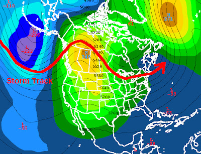
This will be caused by an upper level high developing on Thursday over the central U.S. causing the storm track to go to the north and keeping us dry.
The image below shows the upper level high driving the jet stream to the north.
Now look what happens the Monday after that
The high develops even stronger over our area pushing the storm track way into Canada.
Once we get past the middle of February our chances of an arctic outbreak will keep getting smaller, so it is possible but unlikely that we will get an arctic outbreak this winter.
My forecast:
Timberline Forecast:
Saturday: Partly sunny, with a high near 39. West northwest wind between 13 and 15 mph, with gusts as high as 22 mph.
Saturday Night: Mostly cloudy, with a low around 26. Breezy, with a west southwest wind between 20 and 23 mph, with gusts as high as 34 mph.
Sunday: Snow. High near 35. Windy, with a west southwest wind around 30 mph, with gusts as high as 46 mph. Chance of precipitation is 90%. New snow accumulation of 3 to 7 inches possible.
Sunday Night: Snow showers. Low around 24. Breezy, with a west wind between 26 and 29 mph, with gusts as high as 44 mph. Chance of precipitation is 90%. New snow accumulation of 8 to 12 inches possible.
Monday: Snow showers likely. Mostly cloudy and breezy, with a high near 32. Chance of precipitation is 70%. New snow accumulation of 3 to 5 inches possible.
Monday Night: Snow likely. Cloudy, with a low around 25. Chance of precipitation is 70%. New snow accumulation of 1 to 2 inches possible.
Tuesday: Snow likely. Cloudy, with a high near 33.
Tuesday Night: Snow likely. Cloudy, with a low around 25.
Thanks for reading
-Michael


No comments:
Post a Comment