Tuesday, January 31, 2012

A Very Dry Start To February.

This February will start out very dry and mild as a big ridge of high pressure will build over us.
the Images below are the CPC 6-10 day outlooks for temperature and precipitation.

Notice how the whole western U.S. is above average in temperature and below average in precip.
This dry weather will be caused by a big upper level ridge developing over us on Wednesday and sending the jet stream way to our north.
The image below is the 00z GFS-WRF showing  the upper level high on Thursday.(indicated by the "H")

This setup will also create quite strong east winds especially near the gorge.
Now the reason for the east wind will be low level high pressure will bottle up against the cascades in the Columbia River valley, and will cause the pressure gradient to be around 7-8mb between PDX and DLS which would give the gorge good winds, but in addition to that a shallow layer of cold air will be present and the big difference in temperature should increase the winds even more.
In the image below the 00Z GFS-WRF shows the high pressure bottled up behind the cascades on Friday. 

If you really like strong wind head up to Crown Point on Friday or Saturday, winds will be gusting around 80-100 mph there!
My forecast:

Timberline forecast:
Wednesday: Snow showers, mainly before 10am. High near 32. West wind around 21 mph, with gusts as high as 33 mph. Chance of precipitation is 80%. New snow accumulation of 1 to 2 inches possible. 

Wednesday Night: A 20 percent chance of snow showers before 10pm. Mostly cloudy, with a low around 24. Northwest wind between 5 and 9 mph. 

Thursday: Mostly sunny, with a high near 35. East southeast wind between 5 and 8 mph. 

Thursday Night: Partly cloudy, with a low around 24. South wind between 9 and 11 mph. 

Friday: Mostly sunny, with a high near 36. 

Friday Night: Partly cloudy, with a low around 25. 

Saturday: Mostly sunny, with a high near 37. 

Saturday Night: Partly cloudy, with a low around 24. 

Sunday: Mostly sunny, with a high near 34. 

Sunday Night: Mostly cloudy, with a low around 24. 
Thanks for reading
-Michael
   

Friday, January 27, 2012

Back to Slow Weather

After this wild middle of January we are now heading into much slower weather pattern . Now what do I mean by "slower"? Well I mean long period of morning fog turning to afternoon sun with occasional shots of rain.
Now what will be causing this?
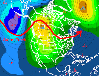
This will be caused by an upper level high developing on Thursday over the central U.S. causing the storm track to go to the north and keeping us dry.
The image below shows the upper level high driving the jet stream to the north.
Now look what happens the Monday after that
The high develops even stronger over our area pushing the storm track way into Canada.
Once we get past the middle of February our chances of an arctic outbreak will keep getting smaller, so it is possible but unlikely that we will get an arctic outbreak this winter.
My forecast:

Timberline Forecast:
Saturday: Partly sunny, with a high near 39. West northwest wind between 13 and 15 mph, with gusts as high as 22 mph. 

Saturday Night: Mostly cloudy, with a low around 26. Breezy, with a west southwest wind between 20 and 23 mph, with gusts as high as 34 mph. 

Sunday: Snow. High near 35. Windy, with a west southwest wind around 30 mph, with gusts as high as 46 mph. Chance of precipitation is 90%. New snow accumulation of 3 to 7 inches possible. 

Sunday Night: Snow showers. Low around 24. Breezy, with a west wind between 26 and 29 mph, with gusts as high as 44 mph. Chance of precipitation is 90%. New snow accumulation of 8 to 12 inches possible. 

Monday: Snow showers likely. Mostly cloudy and breezy, with a high near 32. Chance of precipitation is 70%. New snow accumulation of 3 to 5 inches possible. 

Monday Night: Snow likely. Cloudy, with a low around 25. Chance of precipitation is 70%. New snow accumulation of 1 to 2 inches possible. 

Tuesday: Snow likely. Cloudy, with a high near 33. 

Tuesday Night: Snow likely. Cloudy, with a low around 25. 
Thanks for reading 
-Michael
 

Monday, January 23, 2012

Last Round of Rain Then Dry.

I haven't posted in a while due to a busy schedule...anyways lets recap last week.
PDX officially received 2.2 inches of snow from the system on Tuesday night,  on Friday lots of flooding happened in the Salem area due to 5-6 inches of rain in 3 days.
Also the ski resorts had lots of new snow, the image below shows 1 week snowfall totals as of 1/22/12

Now tomorrow a warm front will bring a large amount of moisture to our area (image below)
Rainfall totals will be around 1-2 inches in the valley and 4-5 inches in the coast range 
After this system clears out of here on Thursday night a ridge of  high pressure will develop and push the jet stream up to our north, which makes the storms from the pacific ride over the high pressure. (image below)
 Now due to the high pressure we will most likely get an inversion due to the lack of mixing, which will create fog.
My forecast:

Timberline Forecast:
Tuesday: Snow before 4pm, then rain and snow. The snow could be heavy at times. High near 32. Windy, with a south southwest wind around 32 mph, with gusts as high as 50 mph. Chance of precipitation is 100%. New snow accumulation of 9 to 13 inches possible. 

Tuesday Night: Rain. Snow level 7000 feet. Steady temperature around 31. Windy, with a west wind between 38 and 44 mph, with gusts as high as 70 mph. Chance of precipitation is 100%. New precipitation amounts between three quarters and one inch possible. 

Wednesday: Snow. High near 34. Windy, with a west wind around 31 mph, with gusts as high as 50 mph. Chance of precipitation is 90%. New snow accumulation of 3 to 7 inches possible. 

Wednesday Night: Snow. Low around 27. Southwest wind between 18 and 21 mph, with gusts as high as 31 mph. Chance of precipitation is 100%. New snow accumulation of 7 to 11 inches possible. 

Thursday: Snow. High near 32. Breezy. Chance of precipitation is 80%. New snow accumulation of 3 to 5 inches possible. 

Thursday Night: A 20 percent chance of snow showers. Mostly cloudy, with a low around 23. 

Friday: Mostly sunny, with a high near 33. 

Friday Night: Partly cloudy, with a low around 25. 
Thanks for reading
-Michael

Wednesday, January 18, 2012

Snow Totals.

Here are snowfall totals from today's storm (in inches)
Washington:
  1. Toutle: 18"
  2. LaCenter: 13"
  3. Yacolt: 12"
  4. Longveiw: 9"
  5. Carson: 7.5"
  6. Stevenson: 6"
  7. Camas: 4.75"
  8. Battle Ground: 4.5"
  9. Vancouver 3"
Oregon:
  1. Parkdale: 13"
  2. Rainier : 12"
  3. Forest Grove: 11"
  4. Scappoose: 10"
  5. Hood River: 8"
  6. Happy Valley: 4"
  7. Portland: 2"
Now what was the reason for the snow switching over to rain? 
Here let me explain with this image
While we were in the cold air the low pressure came and gave us moisture. Now early this morning a warm front came and brought us warm air and it changed over to rain.
Here are a few images of today's snowfall
Dufur, Oregon
 Vernonia, Oregon, taken by Garrey Kinney
Forest Grove, Oregon, taken by Erik Lentz
  Cascade Locks, Oregon, Taken by Serge Tishchenko
My Forecast:
Timberline Forecast:
Tonight: Snow. The snow could be heavy at times. Temperature rising to around 29 by 4am. Windy, with a west southwest wind between 29 and 34 mph, with gusts as high as 45 mph. Chance of precipitation is 90%. New snow accumulation of 12 to 18 inches possible. 

Thursday: Snow. The snow could be heavy at times. High near 32. West southwest wind around 15 mph. Chance of precipitation is 100%. New snow accumulation of 20 to 26 inches possible. 

Thursday Night: Snow. The snow could be heavy at times. Low around 24. West wind between 9 and 16 mph, with gusts as high as 20 mph. Chance of precipitation is 90%. New snow accumulation of 5 to 9 inches possible. 

Friday: Snow. High near 30. Southwest wind between 15 and 21 mph, with gusts as high as 24 mph. Chance of precipitation is 90%. New snow accumulation of 4 to 8 inches possible. 

Friday Night: Snow. The snow could be heavy at times. Low around 23. Breezy. Chance of precipitation is 100%. New snow accumulation of 10 to 14 inches possible. 

Saturday: Snow. High near 29. Breezy. Chance of precipitation is 90%. New snow accumulation of 5 to 9 inches possible. 
Thanks for reading
-Michael

Tuesday, January 17, 2012

Tonight's Snow Event.

We are currently under a winter storm watch and it will be updated to a winter storm warning soon.
My thoughts on tonight's snow:
  • Now-8pm: rain/snow showers, snow above 500ft, turning to all snow
  • 8pm-4am: snow, heavy at times 
  • 4am - 10 am: a warm front will come through and depending on the placement of the low the timing of the switch to rain will vary by location.
Accumulation:
  • South of PDX: 0 to 1 inch switch to rain at 2-3 am.
  • PDX: 1-3 inches switch to rain at 4 -5 am.
  • Clark County: 3-5 inches: switch to rain at 6-7 am.
Now why is the timing of the switch to rain so difficult? It is difficult because it all depend on the track of a low pressure system, If the system tracks to the north of Portland we would get strong south wind and switch to rain around 3 am . If the system goes over PDX then we would switch to rain around 6am,
Here is the 24 hour snowfall total ending at Wednesday 4pm      


Sunday, January 15, 2012

Wild Week With More Snow and a Possible Windstorm.

Today morning many of you woke up with a dusting of snow. The official Portland snowfall total is 0.5 inches.
   Now will it Snow again?
Some showers today will produce snow
The best chance for sticking snow once again will be tomorrow starting around 7pm.
On Tuesday the forecast is difficult, the GFS model suggests we warm up quickly, the euro model suggests that we warm up slowly in the afternoon, But the NAM model says that the 850mb temp will be around -7 to -8c (borderline for snow) all day. All of the models say there will be moisture available on Tuesday,
Now on Wednesday the chance of snow will depend on the placement of the low, too far north and we get rain.
The image below  shows the GFS placing the low (red) to the north of Astoria, however for us to get snow the low must be in the blue zone.
End of the week:
all models are hinting at a very deep low coming in some time Thursday-Saturday. Now what does a deep low do? A deep low gives us a big pressure gradient witch gives us strong wind.
the image below is the 18z GFS on Friday
The pressure gradient from Eugene to Olympia is about 14mb witch would give us wind gusts of 45-50 mph
My forecast:
Timberline Forecast:
Tonight: Snow showers. Low around 9. Wind chill values as low as -10. West northwest wind around 18 mph, with gusts as high as 26 mph. Chance of precipitation is 80%. New snow accumulation of 2 to 4 inches possible. 

M.L.King Day: Snow showers. High near 14. Wind chill values as low as -10. Windy, with a west wind 21 to 24 mph increasing to between 29 and 32 mph. Winds could gust as high as 45 mph. Chance of precipitation is 100%. New snow accumulation of 3 to 5 inches possible. 

Monday Night: Snow showers. Low around 12. Wind chill values as low as -10. Windy, with a west wind between 28 and 33 mph, with gusts as high as 47 mph. Chance of precipitation is 100%. New snow accumulation of 7 to 11 inches possible. 

Tuesday: Snow showers. High near 20. Windy, with a west wind between 28 and 30 mph, with gusts as high as 41 mph. Chance of precipitation is 100%. New snow accumulation of 10 to 14 inches possible. 

Tuesday Night: Snow. Low around 14. Windy. Chance of precipitation is 100%. New snow accumulation of 11 to 17 inches possible. 

Wednesday: Snow. The snow could be heavy at times. High near 30. Windy. Chance of precipitation is 100%. New snow accumulation of 15 to 21 inches possible. 
Thanks for reading
-Michael

Saturday, January 14, 2012

Quick update on Snow.

Quick late night post, will post more tomorrow
As many of you have seen we are getting snow showers mixing down into the lowest elevations.
Now some media has really hyped this event saying "Winter Storm" yet there live crews were standing in partly cloudy conditions.
So how much and where will it snow?
Trace to 2 inches is possible anywhere from tonight through Monday evening.
The only problem is that the shower are limited. The good news is that the HRRR model (below) is showing some snow being able to accumulate tonight.
In other words don't be surprised if you don't have snow but across town someone is saying they have over an inch of snow.
My forecast:

Wednesday, January 11, 2012

Outlook on Snow.

As many of you have heard this weekend we might end up having snow, here are my thoughts on this...
First off very often when we have chances of snow we end up being too dry for snow this time however this time there will be plenty of moisture but not much cold air. Let me explain, for snow down here at the valley floor we need the 850mb (5,000ft) temp to be -8c or lower, so lets take a look at what the models say.
All the models agree on the 850mb temp on being -7 to -9c (very borderline for snow).
Now here's the problem, during this period there will be a slight south to north pressure gradient giving us a light southwest wind. Now whats the problem with southwest wind? The problem is the southwest wind is a warm wind and has killed many snow chances in the past.and this time they will probably give us rain/snow mix or very wet snow. 
Where and how much will it snow?
Sunday-Monday
Lets go by elevation.(keep in mind this could change)
1500ft+:6-12 inches 
500-1500:1-4 inches
Valley floor: trace-1 inch 
Now there is great news for ski resorts that are suffering from lack of snow.
The image below is a forecast of 24 hour snowfall ending on Wednesday afternoon.
Over 30 inches (3 feet of snow!) in the cascades! that will put ski resorts back into business.
My forecast:


Timberline Forecast:
Thursday: Sunny, with a high near 32. Wind chill values as low as -16. East southeast wind around 14 mph. 

Thursday Night: Mostly clear, with a low around 7. Wind chill values as low as -4. South southeast wind between 6 and 10 mph. 

Friday: Sunny, with a high near 38. Calm wind. 

Friday Night: Partly cloudy, with a low around 10. South southwest wind around 6 mph. 

Saturday: Rain showers likely, mainly after 4pm. Snow level 6300 feet lowering to 5200 feet. Partly sunny, with a high near 40. Chance of precipitation is 60%.

Saturday Night: Rain and snow showers likely, becoming all snow after 10pm. Cloudy, with a low around 12. Chance of precipitation is 70%. Little or no snow accumulation expected. 

Sunday: Snow showers. Mostly cloudy, with a high near 12. 

Sunday Night: Snow showers likely. Cloudy, with a low around 2. 

M.L.King Day: Snow showers. Cloudy, with a high near 17. 

Monday Night: Snow showers likely. Cloudy, with a low around 4. 
Thanks for reading
-Michael   

Monday, January 9, 2012

Very Inconsistent Models and Berried in Snow

Before I get to the inconsistent models I want to talk about were the snow has been.
So far this winter the whole nation has had very little snow. Well now it appears now that we have found where it has been...
The answer is...Alaska! yep Alaska just look at these photos by a member of the pacific northwest weather group in Cordova Alaska.
The town is literally Berried! Cordova's average yearly snowfall is 127 inches but so far this year over 216 inches (18 feet) has fallen and it has not stopped snowing for over 24 days in a row! The town has declared a state of emergency and the Alaskan coast guard is helping them clear the snow.  
Here is another image of a ski lift on Mt. Eyak near the town.
Yes that little thing poking out is the chair lift!
and just one more photo to show how much snow there is
Now back to our weather...
Long term:
Models are still being very in consistent starting around Sunday night, however the European model (witch is one of the more reliable models) is showing a trend to colder weather.
The image below shows the 12z euro ensembles(separate models that support)
Note: for snow the 850 mb temp must be -8c or lower.
In the image notice how many of the ensembles take the 850 mb temp down to -8--10c. Meanwhile the GFS has 850mb temps at 0-5c at the same time.
My Forecast:
Timberline Forecast:
Tuesday: Mostly cloudy, then gradually becoming sunny, with a high near 30. Northwest wind between 3 and 11 mph. 

Tuesday Night: Mostly clear, with a low around 24. East wind between 6 and 11 mph. 

Wednesday: Sunny, with a high near 33. East wind between 3 and 10 mph. 

Wednesday Night: Partly cloudy, with a low around 22. Light southeast wind. 

Thursday: Mostly sunny, with a high near 34. 

Thursday Night: Partly cloudy, with a low around 24. 

Friday: Partly sunny, with a high near 34. 

Friday Night: Mostly cloudy, with a low around 25. 

Saturday: A slight chance of snow. Mostly cloudy, with a high near 34. 
Thanks for reading 
-Michael


Friday, January 6, 2012

Interesting Model Runs and a Dry Weekend .

I have not posted for awhile now due to a vacation I took, anyways moving on...
Before I talk about the short term I want the talk about the long term.
Models runs in the long range are being very inconsistent  however there is a trend toward more cool weather
let me show you what I mean by inconsistent...
This image is of the last 4 GFS model runs, now pay attention to the 850mb (5,000ft) circled in red.
Notice how the 12z  got rid of the arctic air then the next run brings it back.
Now for us to get snow the 850 mb temp has to be -8c or lower.
Also the ensembles (separate model runs) are not totally agreeing with the model
Here is a look at the ensembles.
Notice how the operational run is one of the runs that stick out .
bottom line is that the arctic air is still up for debate .
Short term:
After today's system a ridge of high pressure will develop and give us dry weather for the weekend. Then on Monday a shortwave will come through giving us rain. Then on Tuesday a big ridge of high pressure will build over our area (indicated in red in the image below) giving us dry weather till next Saturday.

Forecast: I'm trying a new graphic
Timberline Forecast:
Tonight: Snow. Low around 25. West wind around 15 mph becoming south. Winds could gust as high as 20 mph. Chance of precipitation is 80%. New snow accumulation of 1 to 2 inches possible. 

Saturday: Partly sunny, with a high near 32. West northwest wind around 8 mph. 

Saturday Night: Partly cloudy, with a low around 27. West northwest wind between 6 and 8 mph. 

Sunday: Sunny, with a high near 38. West wind around 7 mph. 

Sunday Night: Partly cloudy, with a low around 27. 

Monday: A slight chance of rain. Snow level 6900 feet. Mostly cloudy, with a high near 40. Chance of precipitation is 20%.

Monday Night: Snow likely. Mostly cloudy, with a low around 28. 

Tuesday: Mostly sunny, with a high near 36. 
Thanks for reading 
-Michael