Saturday, March 24, 2012

Spring is Finally Here

Today was a very warm day just 2 days after our latest recorded snowfall in history at PDX
Today PDX hit 64 and that is just 2 days after a record breaking snow event.
Here is an image of the ducks stadium on Wednesday morning. 

 So the question is, is Spring here to stay? Well yes, let me explain.
Lets start at looking at what an average spring is here in the PNW,
The image below shows our average temperature for the spring months.
If you notice our regions average temperature ranges from 50-60 degrees
now lets take a look at the precipitation
According to this our region receives over 10 inches of rain in the spring months. 
So whats in our future? 
The image below shows the 18z GFS ensemble 850 mb temps (the red line represents average) 
 Notice how most of the ensembles stay around climatology meaning the high temperatures will stay in the 45-65 range through the next 16 days which is very close to our spring average
I will not post for the next 9-11 day due to a vacation I will be on.
My Forecast:
Thanks for reading 
-Michael

Monday, March 19, 2012

Flooding Rains and a Cascade Snowstorm.

After a week of cold wet weather with a few snow showers on Sunday we are continuing this stubborn weather that just wont go away.
Starting tonight a big slug of moisture will begin hitting it us bring lots of rain through the next 2-3days.
So just how much rain? Well models are showing the 3 day rain fall totals reaching near the 3 inch mark. Now if that much rain will fall then there could be some serious flood threats to already high rivers.
The image below is the 3 day rainfall forecast ending Thursday morning
Now this rain will not be a warm pineapple express  but instead a cold frontal 40 degree rain. The thing is this being a cold rain will mean snow up in the hills. Now a usual precip to snow ratio is 1 to 10 inches, which means 1 inch of rain is equal to about 10 inches of snow and if you look at the forecast rain totals above and change that to snow, places in the Cascades could get nearly 3 feet of snow in the next 3 days.
 The image below shows the 24 hour forecast snowfall totals ending 5pm Wednesday   
Ranging from 20 to 40 inches in spots!
Later in the evening on Wednesday as the cold front begins to move things could get interesting. Cold air advection will begin taking place and bottling up cold air along the west slopes of the Cascades. This will lead to lowering snow levels, now if the enough cold air bottles up it could lower the snow level down to the valley floor in the eastern part of the metro area, such as Battle Ground, Gresham, Oregon City, Camas...ect. But for now I am saying that we will only get a rain/snow mix with the snow level staying above 500ft.
Thanks for reading 
-Michael 

Tuesday, March 13, 2012

Historic Coastal Snow Storm

What a wild few days of weather it has been! Lets start off with the wind.
Early Monday morning a deep low pressure rapidly developed and gave the coastal areas and some valley locations very strong winds.
The image below is a water vapor satellite image of the low
  Here are some of the peak gusts recorded
- Pacific City (87mph)
- Garibaldi (82mph)
- Cape Foulweather (81mph)
- Clatsop Spit (81mph)
- Lincoln City (77mph)
- Cape Disappointment (75mph)
- Cannon Beach (65mph)
- Ocean Park (56mph)
- Salem (56mph)
- Eugene (51mph)
- Portland (49mph)
- Kelso (43mph
)

Later on in the day the cold front passed the coast and started to drop the temperatures. Pretty quickly the rain began to turn to snow and stick. Meanwhile here in the Portland area we were getting heavy rain.
In the evening something almost unheard of  happened, Lincoln city was getting dumped on with snow meanwhile Government camp was getting rain
Here are the ODOT images taken at the same time.

Now what caused this phenomenon to happen? 
This was caused by a cold front stalling out just to the east of the Portland area and providing lots of moisture to the whole area, but the cold front stalling just to the east of the metro area caused the cold air at the coast  not to be pulled in to our area until later when the front began moving again..
The image below shows the location of where the front stalled out (blue barbed line)
In fact so much snow fell on the cost that it will be one that goes down in the record books
So how much snow did fall?
Coast:
Tillamook: 8.5 inches
Newport: 6.0 inches
Waldport: 6.0 inches
Florence: 5.0 inches
Valley:
Happy Valley: 5.0 inches
Boring: 4.0 inches
Camas: 2.0 inches
Milwukie: 1.2 inches
 Salem: 1.0 inch
SE Portland: 1.0 inch

Forecast:
The next several days are just going to be very wet, models are showing the jet stream taking aim directly at us and bringing us lots of moisture.
The image below is the NOGAPS model showing the jet stream on Thursday
On Saturday and Sunday another cold batch of air will come down, now snow is not looking likely due to the lack of precipitation with this cold air.
 The image below shows the jet stream buckling and allowing the cold air to come down 
My forecast:
Thanks for reading
-Michael

Sunday, March 11, 2012

Coastal Bomb

Tonight a major storm in the Pacific will develop very rapidly
 Now this rapid intensification is called a meteorological bomb which means the pressure has dropped 24 millibars in 24 hours.
  Here is an image of the low at 2pm Sunday
It might be hard to see but the small low is at 998 millibars
Here is that low 15 hours later heading toward Van. Island
Notice its down to 974 millibars! That is 24 millibars in 15 hours!  
Now if this storm would come 100 miles more to the east then we would be in for a big storm here in the Portland area. 
Here is the 12z WRF-GFS wind gust forecast
Notice how there are 70+ knot (80 mph) wind gusts along the coast...so if you want to go storm watching head on over to the coast tomorrow, as for us in the valley we will only receive a breezy 25 to 30 mph wind with a few gusts near 40 mph.
Thanks for reading
-Michael 

Thursday, March 8, 2012

Back to Stormy and Wet.

Well I hope you enjoyed the last few days of sun because starting tomorrow night the rain is back.
Today was the warmest day so far in 2012, PDX officially hit 65 degrees with some places hitting near 70.
Now tomorrow  as the day progresses clouds will roll in but the the front with the rain should hold till the overnight hours. After this front the jet stream will take aim directly at us.
The image below shows the jet stream taking aim at us on Saturday
As you can see the Jet stream delivers lots of moisture with it which gives us rain.
Now the catch is this jet stream is not moving anywhere, here it is again next Thursday
So just how much rain will we get?
Well the 12z WRF-GFS below gives us 1.5 inches of rain in 72 hours by Tuesday morning
Also on Monday a deep low pressure system will pas to our northwest giving the coast winds sustained near 60mph, now depending on how far west this low pressure will go will depend if the valley will get good wind.
The image below is the 00z WRF-GFS showing the low pressure producing winds of 50 knots of the coast.
My forecast:
Thanks for reading
-Michael

Saturday, March 3, 2012

Weather Roller Coaster

Last Wednesday night the forecast went wrong instead of having some light snow showers we got almost a widespread inch of snow with 2 inches in some places.
Now what went wrong?
Models were showing the big surface low moving off tho the east and drying us out, now that did happen but what models did not depict is that small little disturbance (called a vorticity maximum) would approach our area  and give us steady precipitation.
The image below shows the little disturbance approaching our coast.
Now moving on to this week. After a warm and dry day on Sunday a cold front will come though our area on Monday afternoon and drop snow levels down to 500-1000ft once again
The best chance for valley snow will be after about 10 pm till Tuesday morning before the air drys out.
The image below shows the sharp cold front coming through on Monday afternoon

Now the following Wednesday high pressure will build over our area giving us possibly of first 60 degree day.
The image below is the 12z GFS ensembles showing the weather roller coaster then lots of disagreement beyond Friday.
 My forecast:

Thanks for reading
-Michael 

Tuesday, February 28, 2012

Update on Snow.

As many of you heard already there is a chance of snow tonight and tomorrow.
Now this evening the chance of sticking snow is very low, however tonight around 11pm a cold front will come through and bring the snow levels down to about 500-1000ft 
The Image below shows the placement of the cold front at 4:30pm

What to expect:
Now-11pm:
  • Rain/snow turning to all rain
  • Breezy winds becoming southerly
 
11pm-11am:
  • Rain/Snow showers becoming all Snow
  • Accumulations will stay mostly above 500ft
  • Accumulations below 500ft will be brief and only a trace -1 inch
12pm +
  • Snow showers will become rain/snow showers
  • T'storms will be possible as the air will be unstable
Long range:
In the long range models are in disagreement just look at the ensembles below some say warm weather other say it will stay cool 

My forecast:
Thanks for reading
-Michael 

Saturday, February 25, 2012

A Snowy Update

I'm sure most if not all have already seen some snow mixing in with rain today but its not over yet.

Info on snow:
  • Everyone will see snowflakes.
  • Best chance for snow will be tonight and Sunday morning
  • Spotty accumulations of a trace to1 inch
  • Accumulating snow will mostly stay above 500ft
  • Daytime highs 40-45
  • Sun breaks will melt any accumulated snow below 1000ft
  • Sunday evening moisture dissipates and leaves us dry
  • Monday will be cool and dry
Tuesday:
Now Tuesday morning models are not all in agreement on the position of a low but if that low does come far enough south then we would get an offshore flow which would give us a snow to rain transition.
The image below is the 12z WRF-GFS on Tuesday morning
Notice how the wind barbs circled in red are pointed offshore that indicated wind blowing from the east.
The image below is an explanation of the setup that we will have.
Now is this does setup right we could get 1-2inches of snow then rain. But if the low tracks farther north then we will get south winds and rain.
My forecast:

Thanks for reading
-Michael 


Wednesday, February 22, 2012

Too Warm in the Lowlands for Snow.

As I mentioned in the last post a trough of cold air is going to arrive over us this weekend.
Saturday the 25th

Now earlier this week models were supporting temperatures cold enough for snow down to sea level. however over the past few days models have warmed that cold air just slightly but enough to not give us snow.
The image below is the WRF-GFS cross section forecast
The dotted purple line is 32 degrees or freezing  the solid blue line represents 1000ft, notice how the dotted line barely goes below the 1000ft mark.
Also when the coldest air arrives in Monday the air dries out and we have no precip.
   So what will we see? 
  • Snow levels 1000-1500ft
  • Possible rain/snow mix in showers Sunday night
  • NO ACCUMULATING SNOW in the valleys.
  • Scattered cold rain showers
  • Cold but dry Monday morning
My forecast:

Sunday, February 19, 2012

Colder Weather Pattern with a Possibility of Snow?

For the past few weeks we have been in a relatively warm and quiet weather pattern. Starting next week end a cold trough from the north will drop down and bring us cold air.

Now models are still disagreeing on exactly how cold the air will be but most are in agreement that it will be between -6 to -8c at 850mb (5000ft) over our area. now in the middle of winter -8c at 850mb will give you snow however during this time of year we would need about -9c to produce snow with an onshore flow.
2 Problems for snow:
1. Onshore flow: 
The image below explains how onshore flow is a problem for snow.
2. Its the end of February:
At the end of February the sun angle is higher which gives us warmer temperatures. 
Bottom line:
  • Snow level will be most likely be around 1000ft.
  • Best chance of brief accumulation at the valley floor would be Sunday morning.
  • Any accumulation would be spotty and brief. 
  • this is one week away and it could change.
My forecast:
Thanks for reading 
-Michael

Thursday, February 16, 2012

One Last Grasp of Winter.

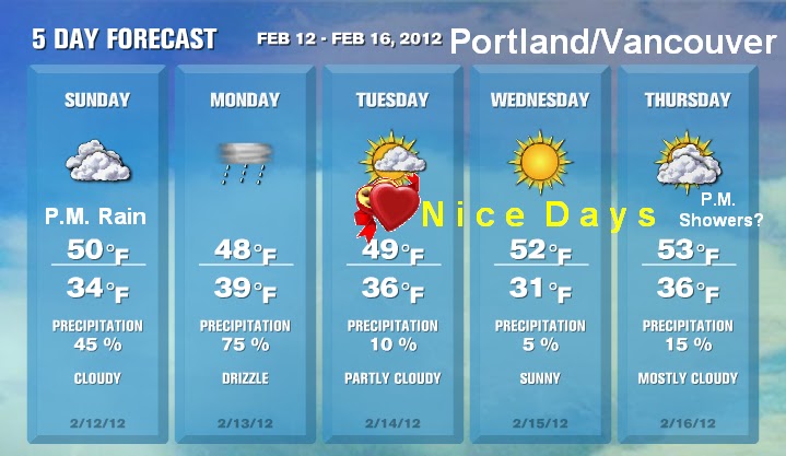
As I explained in my last post that after we enter March our chances of lowland snow/arctic blast decreases dramatically.
However winter has decided to attempt to visit us one last time. 
Saturday-Monday (18th-20th):
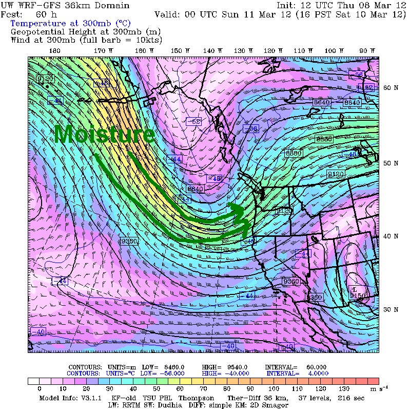
 A trough of low pressure will arrive over our area and allow some cold air to seep into our region (shown below). Now this cold air will lower the 850 mb (5,000ft) temps down to about -6c which means the snow levels will be 1,000 ft to 1,500ft. Now the snow levels being up there does not rule out the chance of a rain/snow mix down to almost sea level in the heavier showers. 
The image below is the 18z GFS ensembles showing the trough over our area on Saturday. 
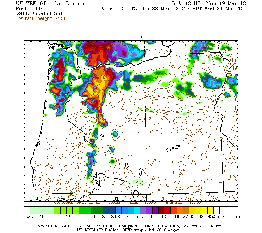
Tuesday-Thursday(21st-23rd):
A ridge of high pressure will build just to the west of us and give us drippy conditions.
The image below shows the 12z WRF-GFS showing the setup.
Notice how the high pressure gives us an onshore flow. Now what does an onshore flow do? Well it usually gives us lots of low clouds, fog, or drizzle. This is also known as a "Dirty Ridge" 
Saturday+ (25th+):
Models are now starting to agree on that a trough of low pressure will drop down over us and drop snow levels down to 500-1500ft. However how low the snow level goes will depend on where the upper level high will be located.
The image below is the 12z Euro ensembles showing the trough bringing cold air to our region.
My forecast:

Timberline Forecast via NWS:
Friday: Snow, mainly after 10am. High near 34. Southwest wind between 17 and 21 mph, with gusts as high as 31 mph. Chance of precipitation is 90%. New snow accumulation of 2 to 4 inches possible. 

Friday Night: Snow showers. Low around 19. Breezy, with a west southwest wind around 25 mph, with gusts as high as 40 mph. Chance of precipitation is 100%. New snow accumulation of 5 to 9 inches possible. 

Saturday: Snow showers. High near 21. Wind chill values as low as zero. Windy, with a west wind between 26 and 30 mph, with gusts as high as 48 mph. Chance of precipitation is 100%. New snow accumulation of 6 to 10 inches possible. 

Saturday Night: Snow showers. Low around 16. Breezy, with a west wind between 20 and 28 mph, with gusts as high as 45 mph. Chance of precipitation is 100%. New snow accumulation of 5 to 9 inches possible. 

Sunday: Snow likely, mainly before 10am. Mostly cloudy, with a high near 26. Chance of precipitation is 70%. New snow accumulation of 1 to 2 inches possible. 

Sunday Night: Snow likely. Mostly cloudy, with a low around 20. Chance of precipitation is 60%. New snow accumulation of less than a half inch possible. 

Washington's Birthday: A chance of snow showers. Mostly cloudy, with a high near 30. 

Monday Night: A chance of snow. Mostly cloudy, with a low around 22. 
Thanks for reading
-Michael  

Saturday, February 11, 2012

Is Winter Over?

Well the answer on the calendar is no, but meteorologically it might be over, let me explain.
Here in the Pacific Northwest our winter usually ends after about February 25-28. In March our chances of an arctic outbreak or any lowland snow dramatically decrease, however mountain snow and wind events are still possible. You might be thinking so what, its only the 2nd week of February.
Here  is why I think our lowland winter is over.
Currently we have a big ridge of high pressure sitting just to the west of us causing the storm track (jet stream) to go over us and giving us mild temps. 
Now here is an image of the 18z GFS ensemble mean 500mb heights at hour 288 (2/23/12)
Notice the ridge of high pressure is still sitting there almost 2 weeks from now.
However there is only one last chance of winter that models are hinting at.
The image below is the 18z GFS ensemble mean 500mb heights at hour 324 (2/25/12) 
Notice how the ridge moves to the northwest allowing the cold air to seep in.
Now if this does not happen then our winter is over for the lowlands.
My forecast:

Timberline Forecast via NWS:
Sunday: Increasing clouds, with a high near 32. West wind between 5 and 8 mph. 

Sunday Night: Snow likely. Cloudy, with a low around 23. West southwest wind between 5 and 8 mph. Chance of precipitation is 70%. New snow accumulation of 1 to 3 inches possible. 

Monday: Snow showers likely, mainly before 4pm. Cloudy, with a high near 24. Northwest wind around 8 mph. Chance of precipitation is 70%. New snow accumulation of 1 to 3 inches possible. 

Monday Night: A 30 percent chance of snow showers, mainly before 10pm. Cloudy, with a low around 22. North northwest wind between 6 and 8 mph. Little or no snow accumulation expected. 

Tuesday: A 30 percent chance of snow, mainly after 10am. Mostly cloudy, with a high near 26. Little or no snow accumulation expected. 

Tuesday Night: A 40 percent chance of snow showers. Mostly cloudy, with a low around 21. Little or no snow accumulation expected. 

Wednesday: A chance of snow showers. Partly sunny, with a high near 28. 

Wednesday Night: A slight chance of snow showers. Mostly cloudy, with a low around 27.
Thanks for reading
-Michael


Monday, February 6, 2012

Micro-climates and a Small Pattern Change

This weekend was just gorgeous! Some locations have even received their first 60 degree day on Sunday.
   Now what has been causing this beautiful weather? This is being caused by a big upper level high sitting just to the east of us driving all the weather systems around us.
The image below shows the upper level high making the storm track bend around and over our region. 
I'm pretty sure all of you have felt that east wind out there. The east wind is being caused by low level high being bottled up against the cascades in the Hood River Valley. Winds gusted at crown point up to 77 mph on Friday and are still gusting up to 70 mph today(Monday). However Pressure gradients are still slowly climbing creating some very strong wind ( gusts 50-60) near the gorge.
Micro-climates:
Now this east wind is causing micro-climates, and a very noticeable one is in the Battle Ground/Hockinson area.
To show you this micro-climate, this image shows the temperatures at 12:00 am Monday.
  Notice how the temps outside the red circle are considerably warmer by about 17 degrees in places.
Now What causes this Micro-climate? This is caused my Larch Mt. and Silver Star Mt. Blocking the east wind. You can really well see how the wind is blocked on this WRF-GFS run
Pattern change:
Models are now mostly agreeing on a small pattern change starting tomorrow night due to the upper level high deteriorating. now this pattern change will be more wet than it has been but not a complete washout.  
My forecast:

Timberline Forecast:
Tuesday: Partly sunny, with a high near 34. South southeast wind between 13 and 17 mph, with gusts as high as 29 mph. 

Tuesday Night: A 20 percent chance of snow after 10pm. Mostly cloudy, with a low around 23. South wind 8 to 10 mph becoming west. 

Wednesday: A 20 percent chance of snow. Partly sunny, with a high near 35. West wind between 8 and 10 mph. 

Wednesday Night: Partly cloudy, with a low around 26. West wind between 3 and 10 mph. 

Thursday: Mostly sunny, with a high near 41. 

Thursday Night: Mostly cloudy, with a low around 25. 

Friday: A slight chance of snow. Mostly cloudy, with a high near 38. 

Friday Night: A chance of snow. Mostly cloudy, with a low around 25. 
Saturday: A chance of snow showers. Mostly cloudy, with a high near 34.  

Thanks for reading
-Michael

Tuesday, January 31, 2012

A Very Dry Start To February.

This February will start out very dry and mild as a big ridge of high pressure will build over us.
the Images below are the CPC 6-10 day outlooks for temperature and precipitation.

Notice how the whole western U.S. is above average in temperature and below average in precip.
This dry weather will be caused by a big upper level ridge developing over us on Wednesday and sending the jet stream way to our north.
The image below is the 00z GFS-WRF showing  the upper level high on Thursday.(indicated by the "H")

This setup will also create quite strong east winds especially near the gorge.
Now the reason for the east wind will be low level high pressure will bottle up against the cascades in the Columbia River valley, and will cause the pressure gradient to be around 7-8mb between PDX and DLS which would give the gorge good winds, but in addition to that a shallow layer of cold air will be present and the big difference in temperature should increase the winds even more.
In the image below the 00Z GFS-WRF shows the high pressure bottled up behind the cascades on Friday. 

If you really like strong wind head up to Crown Point on Friday or Saturday, winds will be gusting around 80-100 mph there!
My forecast:

Timberline forecast:
Wednesday: Snow showers, mainly before 10am. High near 32. West wind around 21 mph, with gusts as high as 33 mph. Chance of precipitation is 80%. New snow accumulation of 1 to 2 inches possible. 

Wednesday Night: A 20 percent chance of snow showers before 10pm. Mostly cloudy, with a low around 24. Northwest wind between 5 and 9 mph. 

Thursday: Mostly sunny, with a high near 35. East southeast wind between 5 and 8 mph. 

Thursday Night: Partly cloudy, with a low around 24. South wind between 9 and 11 mph. 

Friday: Mostly sunny, with a high near 36. 

Friday Night: Partly cloudy, with a low around 25. 

Saturday: Mostly sunny, with a high near 37. 

Saturday Night: Partly cloudy, with a low around 24. 

Sunday: Mostly sunny, with a high near 34. 

Sunday Night: Mostly cloudy, with a low around 24. 
Thanks for reading
-Michael