Wednesday, November 30, 2011

Arctic Air Next Week?

Note: this can change
Next week: models today have started hinting at really cold air coming in next week.
The reason for this cold is the upper level high over us currently is going to move west. But how far it moves west will make it depend on how cold it will get.
The image below shows today's mornings 12z GFS-WRF 500mb temps.
Notice how the cold air (purple color) is right over Washington and Oregon
however 
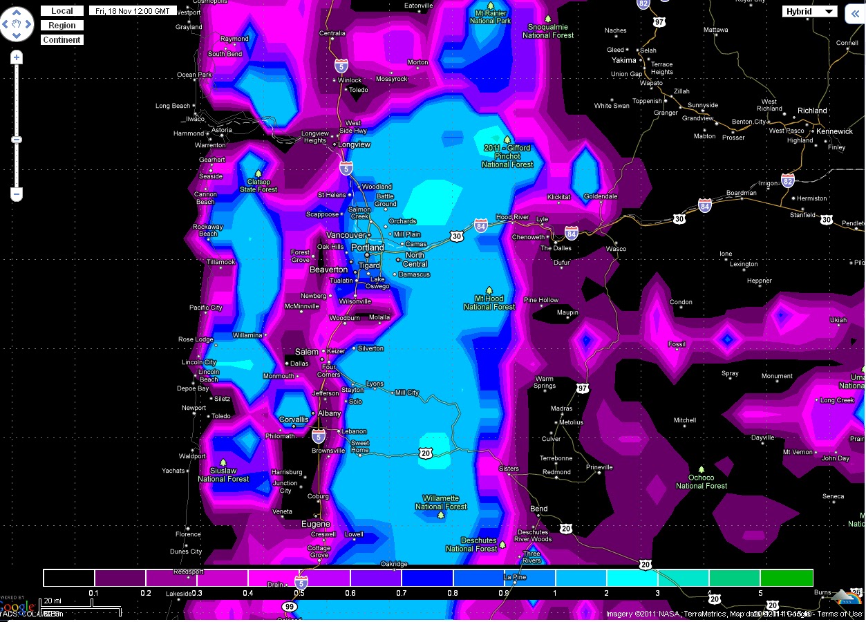
Tonight's 00z GFS-WRF 
Notice how the purple has moved more east on this run 
So bottom line is it will depend on how far this high pressure moves west if it moves not to far then no arctic air, if it moves farther away then we get arctic air.
Also here is a image of the 12z euro ensembles showing the 850mb temps

   Most of them are scattered  but there is a large group that brings the temps down to -10c

For skiers and snow boarders:
Timberline forecast:
Thursday: Sunny, with a high near 34. East wind between 11 and 15 mph, with gusts as high as 18 mph. 

Thursday Night: Mostly clear, with a low around 20. Light wind becoming west northwest between 12 and 15 mph. Winds could gust as high as 20 mph.

Friday: Sunny, with a high near 32. North wind between 7 and 16 mph, with gusts as high as 20 mph. 

Friday Night: Mostly clear, with a low around 24. East northeast wind between 7 and 9 mph. 

Saturday: Sunny, with a high near 34. 

Saturday Night: Mostly clear, with a low around 33. 

Sunday: Sunny, with a high near 35. 

Thanks for reading 
-Michael 

Monday, November 28, 2011

Dry Week Ahead.

Models are now very consistent in showing a large upper level high developing on Thursday just to the west of us and giving us dry weather starting Wednesday afternoon.
On Tuesday overnite into Wednesday a week clipper system will move through the area bringing, light rain fall totals and a few inches of snow down to the mountain passes.
After this system passes a large upper level high develops just to the west of us keeping us dry and models are showing it hanging on until around next Thursday 
the image below shows the 12z GFS-WRF 500mb chart showing the high pressure on Thursday
  watch as it continues on to Saturday 
Along with it this will also bring very high snow levels up to around 7,000-8,000ft
The image below has the 18z GFS showing 850mb (5,000ft) temps
Temps are over 8c in the cascades 
during this time a low level high develops to the east of us giving us light east winds, these winds will cause an inversion (warmer above then below) so daytime highs will only be in the 40s. While the lows in outlying areas will be down into the low 20s

for skiers and snowboarders:
Timberline forecast:
Tuesday: Snow showers likely after 4pm. Partly sunny, with a high near 41. West northwest wind between 5 and 8 mph. Chance of precipitation is 60%. New snow accumulation of less than a half inch possible. 

Tuesday Night: Snow showers, mainly before 4am. Low around 23. Breezy, with a west wind between 18 and 23 mph. Chance of precipitation is 80%. New snow accumulation of 3 to 5 inches possible. 

Wednesday: A 30 percent chance of snow showers, mainly before 10am. Partly sunny, with a high near 32. Northwest wind between 10 and 16 mph. Little or no snow accumulation expected. 

Wednesday Night: Partly cloudy, with a low around 23. East northeast wind between 10 and 17 mph, with gusts as high as 21 mph. 

Thursday: Sunny, with a high near 37. 

Thursday Night: Mostly clear, with a low around 25. 

Friday: Mostly sunny, with a high near 37. 
Thanks for reading
-Michael

Friday, November 25, 2011

Uneventful Dry Week Ahead.

Compared to last week these next two weeks are going to be very calm and dry.
Here is text output of the 18z GFS model from Brian Schmits program.
Note: the high temps are not accurate.
After Sundays cold front comes through Monday and Tuesday look to be dry however a very small system could pass through the area on Wednesday but it will give us very small rainfall totals. After the system on Wednesday models are showing an area of high pressure building up over the area giving us dry weather the rest of the week to put up your Christmas lights.  
The image below shows the 18z GFS model showing high pressure building over the area on Thursday
For skiers ans snowboarders:
Timberline forecast:
   Saturday: A 20 percent chance of rain before 10am. Mostly cloudy, with a high near 39. Southwest wind between 14 and 17 mph, with gusts as high as 22 mph. 

Saturday Night: A 30 percent chance of rain, mainly after 4am. Mostly cloudy, with a low around 30. Breezy, with a southwest wind between 20 and 26 mph, with gusts as high as 33 mph. 

Sunday: Rain before 4pm, then rain, possibly mixed with snow. High near 34. Windy, with a west southwest wind between 30 and 36 mph, with gusts as high as 45 mph. Chance of precipitation is 90%. New snow accumulation of around an inch possible. 

Sunday Night: Snow likely, mainly before 4am. Cloudy, with a low around 26. Breezy, with a west wind between 14 and 22 mph, with gusts as high as 28 mph. Chance of precipitation is 70%. New snow accumulation of 2 to 4 inches possible. 

Monday: A 30 percent chance of snow showers, mainly before 10am. Mostly cloudy, with a high near 33. Little or no snow accumulation expected. 

Thanks for reading!
-Michael

Wednesday, November 23, 2011

Two More Wet Days then a Possible Dry Saturday.

Here are the top 50 rainfall storm totals from the NWS (starting 6am Monday ending 10am Wednesday)

  1. JUNE LAKE,WA..............10.10
  2. SHEEP CANYON, WA...........9.10
  3. CEDAR, OR..................8.65
  4. FRANCES, WA................8.50 ...CORRECTED...
  5. FOSS, OR...................8.06
  6. SOUTH FORK, OR.............7.63
  7. SPENCER MEADOWS, WA........7.60
  8. LEES CAMP, OR..............7.50
  9. LONE PINE, WA..............7.40
  10. COUGAR, WA.................7.24
  11. SPIRIT LAKE, WA............6.50
  12. GRANDE RONDE, OR...........6.30
  13. SURPRISE LAKE, WA..........6.00
  14. LOG CREEK, OR..............5.76
  15. SEINE CREEK, WA............5.70
  16. MILLER WOODS, OR...........5.70
  17. TILLAMOOK..................5.69
  18. SADDLE MOUNTAIN, OR....... 5.50
  19. RYE MOUNTAIN, OR...........5.36
  20. TILLAMOOK RAWS, OR.........5.35
  21. ROCKHOUSE, OR..............5.34
  22. BEAVER, OR.................5.31
  23. NORTH FORK, OR.............5.10
  24. TROUT LAKE, OR.............5.07
  25. JEWELL, OR.................5.00
  26. VERNONIA, OR...............4.93
  27. HORSE CREEK, OR............4.87
  28. SCAPPOOSE, OR..............4.60
  29. FOREST GROVE, OR...........4.49
  30. GASTON, OR.................4.46
  31. SCOGGINS DAM, OR...........4.35
  32. CANNIBAL RAWS, OR..........4.25
  33. CLEAR CREEK NEAR COUGAR, WA4.22
  34. YELLOWSTONE RAWS, OR.......3.91
  35. BONNEVILLE DAM, OR.........3.73
  36. WILKINSON RAWS, OR.........3.54
  37. LITTLE MEADOWS, OR.........3.50
  38. ASTORIA, OR................3.42
  39. ELKHORN MTN, WA............3.39
  40. TROUT CREEK RAWS, OR.......3.35
  41. MCMINNVILLE, OR............3.33
  42. SCOTTS MILLS, OR...........3.20
  43. WANDERERS RAWS, OR.........3.19
  44. VANCOUVER, WA..............3.14
  45. GOODWIN PEAK RAWS, OR......3.14
  46. PORTLAND AIRPORT...........3.12
  47. PEPPER CREEK, WA...........3.10
  48. RED BOX RAWS, OR...........3.08
  49. DETROIT, OR................3.08
  50. HILLSBORO, OR..............3.01
Now on to the forecast:
Tomorrow afternoon yet another front will bring more rain, however totals should only be near half an inch as shown in the image below of the 00z run of the NAM model
This front will bring snow levels down to about 2,500 and snow to the passes.
After the showers behind the front end Friday afternoon things will begin to dry out. However a weak warm front will pass just to the north of us. The good thing is rain is looking likely to stay just north of the metro area as shown in the image below of the 00z model showing the rain boundary right over the metro area.
After yet another front comes through on Sunday models are showing the jet stream lifting north and giving us a possible dry stretch starting Monday.
The image below shows a model forecast of the jet stream on Tuesday
 The jet stream lifts north due to a high pressure building over us and causing the jet steam to go around.


For skier/snowboarders:
Timberline forecast:
Thanksgiving Day: Snow, mainly after 10am. High near 27. Breezy, with a southwest wind between 14 and 22 mph, with gusts as high as 32 mph. Chance of precipitation is 100%. New snow accumulation of 3 to 5 inches possible. 

Thursday Night: Snow. Low around 19. Windy, with a west wind 45 to 48 mph decreasing to between 30 and 33 mph. Winds could gust as high as 70 mph. Chance of precipitation is 100%. New snow accumulation of 8 to 12 inches possible. 

Friday: Snow showers likely, mainly before 10am. Cloudy, with a high near 27. West wind between 11 and 18 mph, with gusts as high as 22 mph. Chance of precipitation is 70%. New snow accumulation of less than one inch possible. 

Friday Night: A slight chance of snow after 10pm. Cloudy, with a low around 25. South southwest wind around 16 mph, with gusts as high as 20 mph. Chance of precipitation is 20%.

Saturday: A 20 percent chance of rain. Cloudy and breezy, with a high near 32.
Thanks for reading
-Michael 

Tuesday, November 22, 2011

Heavy Rain and More to Come!

Today the front stalled over the Portland area and then moved off to the north leaving big rain fall totals.
The image below shows rainfall totals as of 4:30 since midnight.
1.88" at PDX 
2.07" at Scappose 
This image below shows the 24 hour rainfall ending 4:30.
3-4 inches in the coast range! And MT Hebo(not on this map) got 5.01"!
Here is 2 more images of 24 hour rainfall totals in Oregon and Washington from Brian Schmit.


Also there is flooding at seaside on highway 101
 But this flooding concern is not over yet as the front will come over us one again overnight as shown in the model run below, another 1 inch is possible in the metro area adding our storm totals to 3-4 inches     

For skiers and snowboarders : 
Timberline forecast:
Tonight: Snow before 10pm, then rain and snow. Snow level 6500 feet. Low around 28. Windy, with a southwest wind between 39 and 44 mph, with gusts as high as 65 mph. Chance of precipitation is 100%. Little or no snow accumulation expected. 

Wednesday: Rain and snow, becoming all snow after 10am. High near 36. Windy, with a west southwest wind 35 to 38 mph decreasing to between 25 and 28 mph. Winds could gust as high as 49 mph. Chance of precipitation is 100%. New snow accumulation of 2 to 4 inches possible. 

Wednesday Night: Snow showers likely, mainly before 4am. Cloudy, with a low around 23. Breezy, with a west wind 21 to 24 mph decreasing to between 13 and 16 mph. Winds could gust as high as 31 mph. Chance of precipitation is 70%. New snow accumulation of 1 to 3 inches possible. 

Thanksgiving Day: Snow, mainly after 10am. The snow could be heavy at times. High near 25. Southwest wind around 15 mph, with gusts as high as 20 mph. Chance of precipitation is 80%. New snow accumulation of 3 to 5 inches possible. 

Thursday Night: Snow showers. The snow could be heavy at times. Low around 22. Chance of precipitation is 90%. New snow accumulation of 7 to 11 inches possible

Thanks for reading
-Michael

Monday, November 21, 2011

Strong Winds and Flooding!

The strongest storm is the season is barreling down our coast and a wind advisory has been posted for the valley due to a strong surface low that is going to pass by Vancouver  Island
The picture below is the GFS-WRF model showing wind gusts

Gusts in the valley are near 50 knots (57mph)! 
Along with the wind there is also concerns for flooding as the strong pacific jet is bringing an atmospheric river at us. You can see it clearly in this satellite image below.

The reason for flooding concerns is that there is a narrow band of moisture with very heavy rain that will stall somewhere in Oregon or Washington.
 The image below is a 1 forecast hour rain fall total.
As you can see this rain band is very thin but it has rain rates between ..64"-1.28" per hour and this rain band is supposed to stall somewhere between central Washington and northwest Oregon . But models are having trouble deciding were this rain band will stall. Here is what I mean
Yesterdays model:
It shows the band stalling in northwest Oregon and hitting PDX.
Today's model:
 It shows the band stalling in central Washington and hitting SEA. 
So bottom line is that;
  • There will be strong winds (gusts from 45-50 mph) late tonight till tomorrow evening 
  • Flooding depends on where the rain band stalls 
For Skiers and Snowboarders:
 Tonight: Snow. Low around 25. Windy, with a southwest wind between 30 and 34 mph, with gusts as high as 50 mph. Chance of precipitation is 100%. New snow accumulation of 8 to 12 inches possible. 

Tuesday: Snow before 10am, then rain between 10am and 4pm, then snow after 4pm. High near 34. Windy, with a southwest wind 40 to 45 mph increasing to between 55 and 60 mph. Winds could gust as high as 90 mph. Chance of precipitation is 100%. New snow accumulation of 4 to 8 inches possible. 

Tuesday Night: Snow before 10pm, then rain and snow. Low around 25. Windy, with a southwest wind between 39 and 44 mph, with gusts as high as 60 mph. Chance of precipitation is 100%. New snow accumulation of 5 to 9 inches possible. 

Wednesday: Snow. High near 34. Windy, with a west southwest wind 35 to 38 mph decreasing to between 25 and 28 mph. Winds could gust as high as 55 mph. Chance of precipitation is 100%. New snow accumulation of 4 to 8 inches possible. 

Wednesday Night: Snow likely. Cloudy and breezy, with a low around 23. Chance of precipitation is 70%. New snow accumulation of 1 to 3 inches possible. 

Thanksgiving Day: Snow likely. Cloudy, with a high near 25. Chance of precipitation is 70%. New snow accumulation of 3 to 5 inches possible. 


Thanks for reading!
-Michael

Sunday, November 20, 2011

Possible Big Storm and Flooding!

Over the past several years all the flooding events have gone just to the north of us. But today models have given us huge amounts of rain here in the metro area.
Here is the Fox 12 RPM model.
   Nearly 7 inches in Portland!
Here is also the 12z GFS-WRF
It shows over 5 inches of rain!
So today's models are showing big time rain, but it all depends on where this front stalls out since this is a narrow band of heavy rain. But if today models are right the we could have some serious flooding issues and possibly dangerous flooding near small rivers.
This system could also bring some strong winds with it as well.
This image is the 12z GFS-WRF showing wind gusts on Tuesday morning.
Wind gusts are peaking at 40 knots (46mph) in the valley and over 70 knots (80mph) at the coast.
For skiers/snowboarders:
Timberline forecast:

Monday: Snow. High near 28. Wind chill values as low as zero. Windy, with a west southwest wind between 30 and 34 mph, with gusts as high as 46 mph. Chance of precipitation is 100%. New snow accumulation of 5 to 9 inches possible. 

Monday Night: Snow. Low around 25. Breezy, with a southwest wind between 21 and 23 mph, with gusts as high as 29 mph. Chance of precipitation is 90%. New snow accumulation of 8 to 12 inches possible. 

Tuesday: Snow before 4pm, then rain and snow. High near 34. Windy, with a southwest wind between 31 and 40 mph. Chance of precipitation is 90%. New snow accumulation of 7 to 11 inches possible. 

Tuesday Night: Rain and snow. Low around 25. Windy, with a southwest wind between 37 and 44 mph, with gusts as high as 55 mph. Chance of precipitation is 80%. New snow accumulation of 10 to 16 inches possible. 

Wednesday: Snow. The snow could be heavy at times. High near 34. Breezy. Chance of precipitation is 90%. New snow accumulation of 7 to 11 inches possible. 

Wednesday Night: Snow likely. Cloudy, with a low around 23. Chance of precipitation is 60%. New snow accumulation of 1 to 2 inches possible. 


Saturday, November 19, 2011

Very Wet Week Ahead.

Well as predicted there was no snow in the valley although many places did see a rain/snow mix.
Tonight may be the coldest night of the season for many places as lows will dip down into the mid 20s.
This Tuesday ,Wednesday and Thursday are looking wet as a weak pineapple express comes in..

The image below shows the jet-stream dipping down into the tropics and aiming right at us, the non technical term for that is a pineapple express.
As the jet-stream picks up moisture from the tropics the moisture in the form of rain dumps on us in addition to that snow levels will rise up to possibly 6,000 ft which is bad news for skier/snowboarders.

the image below shows the 72 hour forecast ending Wednesday afternoon
Nearly 5 inches in the valley! If this does come true there will be some flooding concerns. 

for skier and snowboarders: 
Timberline forecast: 
Sunday Night: A 30 percent chance of snow after 4am. Mostly cloudy, with a low around 19. Southwest wind between 9 and 13 mph. Little or no snow accumulation expected. 

Monday: Snow likely, mainly after 10am. Cloudy, with a high near 30. Windy, with a west southwest wind between 20 and 30 mph, with gusts as high as 39 mph. Chance of precipitation is 60%. New snow accumulation of around an inch possible. 

Monday Night: Snow likely. Cloudy and breezy, with a low around 24. Chance of precipitation is 70%. New snow accumulation of 3 to 7 inches possible. 

Tuesday: Snow likely. Cloudy and windy, with a high near 36. Chance of precipitation is 60%. New snow accumulation of 3 to 5 inches possible. 

Tuesday Night: Snow likely. Cloudy and windy, with a low around 25.


Thursday, November 17, 2011

Snow Chances Looking Grim and a Weak Storm.

Yesterdays so called storm was not all that impressive as it was forecast. Rainfall total at PDX was only 0.49" at my house however it was 0.93". PDX also reported a gust of wind at 40 mph which is strongest since mid march.
Now on to the snow outlook
Here is the image of the 72 hour snowfall from the 12z rpm model.
   Notice how all the snow is only over around 1,000 ft
Temperatures are going to be just to warm for snow both Friday and Saturday however this does not rule out a chance of rain/snow mix in the valley during heavy showers. So it looks like we didn't get lucky this time but there still is the whole winter left!
As for next week, it is looking wet! just as this model shows the 72 hour precipitation totals.Over 10 inches in the Olympic mountains! and over 2 inches in the valley.

For skiers/snowboarders:
Timberline forecast:
Tonight: Snow showers. Low around 16. Wind chill values as low as -3. Windy, with a west southwest wind between 30 and 34 mph, with gusts as high as 45 mph. Chance of precipitation is 100%. New snow accumulation of 6 to 10 inches possible. 

Friday: Snow showers. High near 16. Wind chill values as low as -3. Breezy, with a west wind between 13 and 22 mph. Chance of precipitation is 90%. New snow accumulation of 4 to 8 inches possible. 

Friday Night: Snow showers likely. Cloudy, with a low around 13. West wind between 8 and 11 mph. Chance of precipitation is 60%. New snow accumulation of 2 to 4 inches possible. 

Saturday: A 50 percent chance of snow showers, mainly before 4pm. Cloudy, with a high near 17. West wind around 9 mph. Little or no snow accumulation expected. 

Tuesday, November 15, 2011

Our Snow Chances.

After Thursdays front we will have some of the coldest air so far this season arrive. Now the Question is will we have snow? First of all lets talk about the main ingredients for snow.

  • First we need cold air which is colder than -8c at 850mb (5,000ft).
  • Second we need moisture .
  • Thirdly we cannot have warm south winds.
  • Lastly if there is an east wind you only need around -6c 850mb temps.
Friday morning:
On Friday morning the 850mb temps are around -6c, which is just to warm for snow in the valley. So most likely snow levels will be around 500ft-1000ft with rain/snow mix down in the valley.
Saturday:
Now this is where things get interesting. 850 temps will be around -7 with an east wind however one thing models are disagreeing on is moisture.
The picture below is the 18Z GFS 
  
It looks good for some snow, the low is not far offshore  giving us east winds, along with moisture coming around the low.
However here is the 12Z euro model
The low is farther offshore and much weaker with no moisture coming up to us.
So bottom line is it all depends on how far off shore the low will go and how strong it will be.
For skiers/snowboarders:
Timberline forecast:

Tonight: A 40 percent chance of snow after 10pm. Mostly cloudy, with a steady temperature around 27. West wind between 8 and 14 mph. Total nighttime snow accumulation of 2 to 4 inches possible.

Wednesday: Snow before 4pm, then rain and snow. The snow could be heavy at times. High near 29. Windy, with a west southwest wind 21 to 24 mph increasing to between 40 and 43 mph. Winds could gust as high as 55 mph. Chance of precipitation is 100%. New snow accumulation of 13 to 19 inches possible.

Wednesday Night: Rain and snow, becoming all snow after 10pm. Low around 26. Windy, with a west southwest wind between 41 and 46 mph, with gusts as high as 55 mph. Chance of precipitation is 100%. New snow accumulation of 8 to 12 inches possible.

Thursday: Snow showers. High near 27. Windy, with a west wind between 31 and 41 mph, with gusts as high as 50 mph. Chance of precipitation is 90%. New snow accumulation of 3 to 5 inches possible.

Thursday Night: Snow showers. Low around 16. Breezy, with a west wind between 22 and 25 mph, with gusts as high as 32 mph. Chance of precipitation is 90%. New snow accumulation of 4 to 8 inches possible. 


Monday, November 14, 2011

Big Soaking This Week

This Wednesday and Thursday will be the biggest soaking in a few months. Valley locations will receive close to an inch of rain in 24 hours as shown in the model below.    

this front will also bring tons of mountain mountain snow, over 20 inches in 24 hours!
The image below shows the 24 hour snowfall ending 4 am Thursday.
This cold front will also bring some of the coldest air so far this season dropping snow levels down to 1000ft
the image below shows the cold air temperature behind the front at 850mb (5,000ft)
Now the question is, will the that air be cold enough to give us snow?
Update: for those who are waiting for snowboarding/ski season here is the forecast on Timberline via NWS
  Wednesday: Snow. The snow could be heavy at times. High near 32. Windy, with a west southwest wind 25 to 28 mph increasing to between 40 and 43 mph. Winds could gust as high as 55 mph. Chance of precipitation is 100%. New snow accumulation of 10 to 14 inches possible. 

Wednesday Night: Snow. The snow could be heavy at times. Low around 29. Windy, with a west wind between 41 and 45 mph, with gusts as high as 60 mph. Chance of precipitation is 100%. New snow accumulation of 8 to 12 inches possible. 

Thursday: Snow showers. High near 30. Windy. Chance of precipitation is 90%. New snow accumulation of 4 to 8 inches possible. 

Thursday Night: Snow showers. Low around 17. Breezy. Chance of precipitation is 80%. New snow accumulation of 1 to 2 inches possible. 

Sunday, November 13, 2011

Snow in Portland on Friday/Saturday?

Models have been suggesting some snow in the Portland metro area such as this one below called the euro model however more recent models are showing that 850 mb temps (temps at 5,000 ft) are going to be above the usually required -8C for snow at sea level. So most likely snow levels will most likely be around 1,000ft and we will not see snow down here in the valley.
Just for fun this is the forecast for MT Rainier:
 Wednesday: Snow. High near 9. Breezy. Chance of precipitation is 100%. New snow accumulation of 36 to 42 inches possible. 

Wednesday Night: Snow. Low around -2. Breezy. Chance of precipitation is 90%. New snow accumulation of 30 to 36 inches possible.
Now that's a lot of snow!


Update:  I forgot to add that Friday night and Saturday morning there is a chance of a rain snow mix down in the valley.
this picture below shows snow only in the mountains on Monday morning but one thing it does not take into consideration is east winds blowing from the gorge. why does that matter? it matters because east winds blow cold air from the gorge in winter time and because of that there could be a transition from snow to rain as the  warm front passes. When the east to west pressure gradient will go away during the front the east wind will stop and snow will transition into rain. Keep in mind this is one week away and could change!